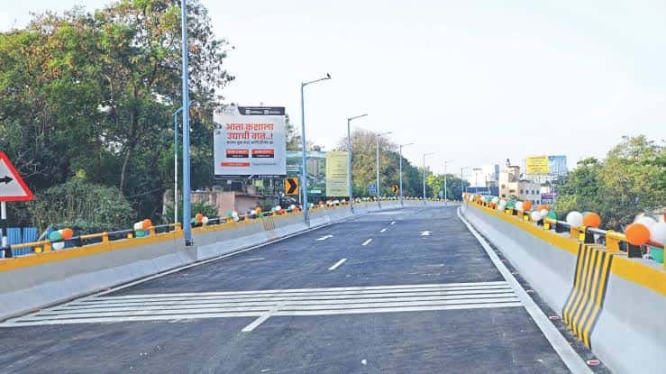
Political parties rarely fight over a flyover opening date, but that’s exactly what happened here — MNS workers protested for weeks, accusing authorities of sitting on a completed structure for reasons that had nothing to do with construction. The pressure worked. Chief Minister Devendra Fadnavis finally cut the ribbon on 1 September 2025, calling it a Ganesh Chaturthi gift to Punekars, and residents who’d spent years stuck in one of the city’s worst daily jams finally got their relief. If you use this stretch regularly, or you’re planning a Sinhagad Fort trek, here’s what actually changed.
Quick Overview
| Aspect | Details |
| Location | Sinhagad Road, from Rajaram Bridge to Fun Time Theatre, Pune |
| Length | 2.6 km, double-decker structure |
| Opened | 1 September 2025 |
| Daily traffic | Over 1.5 lakh vehicles |
| Connects to | Dhayri, Narhe, Khadakwasla, Vadgaon Budruk, Nanded City, Mumbai-Bengaluru Highway |
| Nearest metro | Nal Stop and Deccan Gymkhana (Purple/Aqua Lines) |
Why This Road Genuinely Needed a Flyover for Years
Sinhagad Road connects some of Pune’s fastest-growing residential belts — Dhayri, Narhe, Vadgaon Budruk, Nanded City — directly to the Mumbai-Bengaluru National Highway, and that combination of local commuter traffic and highway-bound vehicles created a bottleneck that widening simply couldn’t fix. The Mutha river runs along one side of this stretch, hills close in on the other, and with nowhere left to expand the road horizontally, a flyover became the only realistic option.
Delays pushed the opening back repeatedly even after construction wrapped up, sparking the MNS protests that eventually forced the issue. Fadnavis, inaugurating the first and second phases together, specifically noted that beyond cutting travel time, the structure should also help lower air pollution along one of Pune’s most congested corridors — a genuine secondary benefit when 1.5 lakh vehicles a day stop idling in traffic.
How to Reach Sinhagad Road Flyover by Road
From Swargate: Head toward Rajaram Bridge, which marks the flyover’s starting point and connects you directly onto the double-decker stretch toward Vadgaon Budruk.
From Dhayri or Narhe: These residential areas sit right along the corridor, feeding directly onto the flyover without needing a long detour.
From Khadakwasla: This route brings you toward the flyover from the reservoir side, useful if you’re combining a Sinhagad Fort trip with city travel.
Toward the Mumbai-Bengaluru Highway: Once you’re on the flyover heading past Fun Time Theatre, the connection to NH4 is now considerably smoother than the ground-level route ever was.
Given how recently this stretch opened, it’s worth checking current traffic patterns occasionally — commuting habits are still settling into whatever the new normal turns out to be here.
Metro Connectivity Near Sinhagad Road
Nal Stop, on the Aqua Line, sits about 18 minutes on foot from Sinhagad Road, running services from 6:00 AM to 11:36 PM. For those closer to the northern end near Sinhagad Road Substation, Deccan Gymkhana on the Purple Line is a similar 17-minute walk, with both lines converging near Swargate for anyone needing to switch.
Given the distance between the metro stations and the actual road, most residents combine a short auto ride with the metro rather than walking the full stretch — a practical workaround until any closer station gets built along this corridor.
Nearby Landmarks Worth Knowing
- Sinhagad Fort — The historic hill fort that gives this road its name, a popular trekking and history destination now easier to reach thanks to the flyover.
- Abhiruchi Mall — A well-known shopping destination right on Sinhagad Road, just a minute’s walk from its own dedicated bus stop.
- PL Deshpande Garden — A recognizable green space near the substation end of the corridor.
- Rajaram Bridge — Marking the flyover’s starting point, a useful landmark for orientation.
- Nanded City — A significant residential township directly connected via this stretch.
Bus Stops and Local Transport Options
PMPML buses cover this corridor extensively, with routes 15, 17, 50, 51, and 52D stopping at points including Abhiruchi Mall, Dhayari Phata, and Vadgaon Budruk Phata. Further along, near Sinhagad Road Exit, routes 43 and 43A serve stops like Navale Bridge Bypass and JK Industries.
For last-mile connectivity, autos operate consistently along the corridor, particularly useful for bridging the gap between the road itself and the nearest metro stations, which sit a genuine walk away rather than right at the roadside.
Best Time to Travel Through Sinhagad Road Flyover
Even with the flyover operational, weekday mornings and evenings still see the heaviest volume, given how many vehicles use this stretch daily to reach the highway or commute within the city. Weekend trekking traffic toward Sinhagad Fort adds another layer, particularly on cooler mornings when the fort draws its largest crowds. If your schedule allows flexibility, travelling outside these windows should now feel considerably faster than it did before September 2025.
FAQs
Q1. Why did the Sinhagad Road flyover opening get delayed despite being completed?
Public frustration grew over what MNS workers called an unnecessary hold-up, with protests eventually pushing authorities to formally open the structure on 1 September 2025.
Q2. How long is the Sinhagad Road flyover, and what does it connect?
It stretches 2.6 km from Rajaram Bridge to Fun Time Theatre, linking Dhayri, Narhe, Khadakwasla, Vadgaon Budruk, and Nanded City to the Mumbai-Bengaluru National Highway.
Q3. Which metro line is closest to Sinhagad Road?
Nal Stop on the Aqua Line and Deccan Gymkhana on the Purple Line are both roughly a 17-18 minute walk away, depending on which end of the corridor you’re near.
Q4. Is this flyover useful for reaching Sinhagad Fort?
Yes — the improved connectivity specifically eases movement for tourists and trekkers heading toward the fort, one of the benefits officials highlighted at the inauguration.

