If you commute along Kalyan-Shil Road between Shilphata and Kalyan, or you live in Lodha’s Palava City township nearby, this flyover has been a genuinely hot topic in recent months. Officially known as the Katai-Nilje Flyover but popularly called Palava Flyover after the massive township it passes near, this structure was built specifically to ease one of the most persistently congested stretches in the Mumbai Metropolitan Region. Whether you’re a Palava resident, a daily commuter on this corridor, or simply trying to understand this route for the first time, here’s a practical, honest look at how this flyover connects everything — including what you should know before using it.
Quick Overview
| Aspect | Details |
| Official name | Katai-Nilje Flyover (popularly called Palava Flyover) |
| Location | Kalyan-Shil Road, between Shilphata and Kalyan, Maharashtra |
| Length | 562 metres, six lanes |
| Built by | Maharashtra State Road Development Corporation (MSRDC) |
| Cost | Approximately Rs 250 crore |
| Nearby township | Palava City (Lodha), a 4,500-acre integrated smart city |
| Public transport options | KDMT buses, internal Palava shuttle buses, Kalyan and Nilaje suburban rail stations |
Why the Palava Flyover Was Built and What’s Happened Since
The Katai-Nilje Flyover was constructed specifically to bisect the busy Diva-Panvel rail route on Kalyan-Shil Road, a stretch that had long struggled with congestion caused by the level crossing here. This road connects Shilphata to Kalyan and passes right alongside Lodha’s Palava City, one of India’s largest integrated townships, spread across 4,500 acres between Thane, Navi Mumbai, and Kalyan.
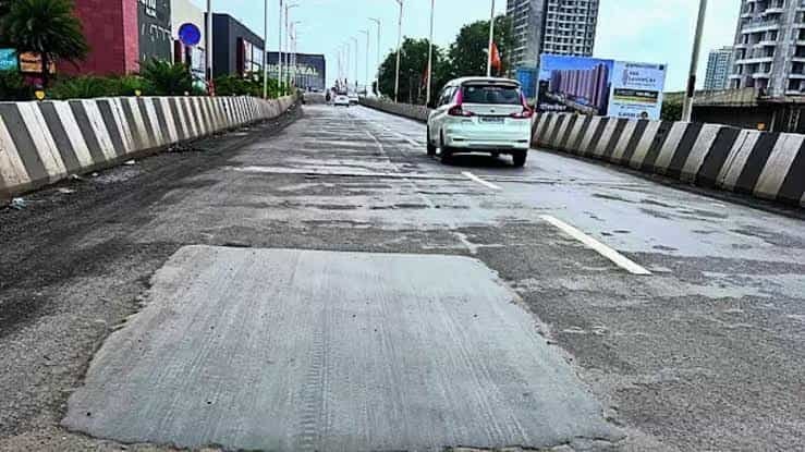
After years of delays and multiple missed inauguration deadlines, the flyover was finally opened for traffic, with six lanes initially made available. However, the launch didn’t go entirely smoothly — within days of its formal inauguration by Shiv Sena MLA Rajesh More on 4 July, the flyover began drawing genuine criticism online. Videos surfaced showing loose gravel, muddy patches, cement spills, and poorly laid tar across a roughly 450-metre stretch of the 562-metre structure, with two bikers reportedly skidding and sustaining minor injuries on the very first day. MSRDC contractors have since been working on the affected sections to address these safety concerns, so if you’re using this flyover, it’s genuinely worth driving cautiously, particularly on two-wheelers, until repair work is confirmed complete.
How to Reach Palava Flyover by Road
From Kalyan: Head toward Shilphata via Kalyan-Shil Road, and you’ll reach the flyover directly — this is the primary route connecting Kalyan to the Palava township and onward toward Shilphata.
From Shilphata or Navi Mumbai direction: Travel along Kalyan-Shil Road toward Kalyan, and the flyover carries you over the Diva-Panvel rail crossing that used to cause significant delays at this point.
From within Palava City: Central Avenue, now open and accessible to Palava residents, connects just 5 minutes off Kalyan-Shil Road, offering effortless access to this corridor and onward to the broader Mumbai Metropolitan Region.
Toward Thane or Navi Mumbai: Palava’s location offers connectivity to Thane via TDLR and to Navi Mumbai via the upcoming Airoli-Katai Tunnel Freeway, making this flyover corridor an important link in the township’s broader transport network.
Given the flyover’s recent surface quality concerns, it’s genuinely worth checking current road conditions before travelling through here, especially during or after rain when loose or muddy patches could pose a greater risk.
Rail and Local Transport Connectivity Near Palava
Nilaje railway station is the nearest suburban rail option to central Palava, while Kalyan railway station remains a major hub for anyone travelling further into Mumbai’s Central Line network. Palava’s own internal mobility system is genuinely well organised — a central HUB near the city’s security gate number 2 serves as the starting point for all buses plying outside the township, with routes connecting residents to key business hubs like Andheri, BKC, Lower Parel, Nariman Point, Airoli, and Ghansoli, several of which are reachable within about 30 minutes.
Dombivli station is specifically highlighted as a key connectivity route for Mumbai’s Central Line, and buses to Vashi are also planned, which would extend Palava’s reach to the Harbour Line and Navi Mumbai’s office hubs as well.
Nearby Landmarks Worth Knowing
The Palava Flyover corridor connects to one of Maharashtra’s most significant planned townships and several important local landmarks.
- Palava City — Developed by Lodha, this 4,500-acre integrated smart city has been recognised as India’s No. 1 smart city in a Jones Lang LaSalle India research report, and is often referred to as the “City of Opportunity.”
- Sai Baba Mandir, Palava — A well-known local temple and bus stop reference point within the township.
- Lodha Complex — A significant residential and commercial hub near the flyover, serving as a key bus stop for the area.
- Kalyan Railway Station — An important suburban rail hub connecting this corridor to the rest of Mumbai’s Central Line network.
- C.C. Cement Company — A notable commercial landmark near Palava Phase 2, used as a local transit reference point.
Bus Stops and Local Transport Options
KDMT (Kalyan Dombivli Municipal Transport Undertaking) buses serve this corridor extensively, with stops including Palava, Lodha Complex, and Palava City Bus Stop connecting residents to Kalyan, Dombivli, and surrounding areas. Within Palava township itself, Lodha operates its own internal bus network, with all internal services running between Downtown/EPIC and the central HUB, and external routes connecting to major Mumbai business districts.
For last-mile connectivity, autos are available near the main bus stops, and given the scale of Palava’s planned transport infrastructure, residents genuinely have more organised options here than in many comparable townships across the Mumbai Metropolitan Region.
Best Time to Travel Through Palava Flyover
Given the flyover’s recent surface issues alongside typical Kalyan-Shil Road congestion, timing and caution both matter here. Weekday mornings and evenings see the heaviest commuter traffic between Kalyan, Shilphata, and Palava, while rainy conditions genuinely warrant extra caution given the reported patches of loose gravel and poor surfacing on parts of the structure. If your schedule allows flexibility, and especially if you’re on a two-wheeler, it’s worth checking recent local updates on repair progress before travelling through this stretch.
FAQs
Q1. Is the Palava Flyover safe to drive on right now?
MSRDC contractors have been actively working on the sections that showed poor surface quality after the July 2025 inauguration, but given the reported skidding incidents, it’s genuinely wise to drive cautiously, particularly on two-wheelers, and check for recent updates on repair status.
Q2. What’s the official name of the Palava Flyover?
It’s officially called the Katai-Nilje Flyover, though it’s popularly known as Palava Flyover because of its proximity to Lodha’s large Palava City township.
Q3. How does Palava’s internal bus network connect to Mumbai’s key business districts?
A central HUB near Palava’s security gate 2 serves as the starting point for all external buses, with existing routes to Andheri, BKC, Lower Parel, Nariman Point, Airoli, and Ghansoli, and additional Vashi services planned to extend Harbour Line connectivity.
Q4. Which railway station should I use to reach central Palava?
Nilaje station is the nearest option for central Palava, while Kalyan station serves as the larger hub connecting this area to Mumbai’s broader Central Line network.

